Home / Weather / UK Weather: Snow Risk Looms as Cold Snap Hits Britain
UK Weather: Snow Risk Looms as Cold Snap Hits Britain
6 Dec, 2025
Summary
- Temperatures in Scotland will hover between 1C-2C.
- The south of England may experience the warmest weather at 7C.
- Met Office warns predicting snow accurately weeks in advance is difficult.

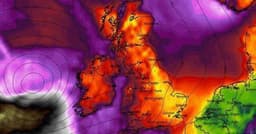
Across the UK, a chilly weather pattern is set to unfold, with Scotland experiencing temperatures between 1C and 2C. Other regions like the North West and Yorkshire and the Humber will see slightly milder conditions around 3C. Meanwhile, the southern parts of England are forecast to be the warmest, potentially reaching 7C.
WXCHARTS maps indicate a possibility of snow in different parts of Britain within the next two weeks. However, the Met Office emphasizes the difficulty in predicting snow with certainty this far out. They explain that the UK's geographical position and the surrounding seas, which remain above freezing, significantly influence air temperatures and thus the likelihood of snowfall.
The Met Office's long-range forecast for December 11-20 suggests a continuation of Atlantic frontal systems bringing rain, sometimes heavy, and intermittent dry spells. While mild conditions are generally expected, a shift towards average temperatures is possible later in the period, with a slightly increased chance of wintry hazards, particularly in northern areas and at higher elevations.