Home / Weather / UK Braces for Snow and Ice Fury
UK Braces for Snow and Ice Fury
16 Feb
Summary
- Yellow weather warnings for snow and ice are active across Scotland.
- Travel disruptions expected for rail, bus, and train services.
- Heavy snow accumulations are predicted for Monday evening and night.
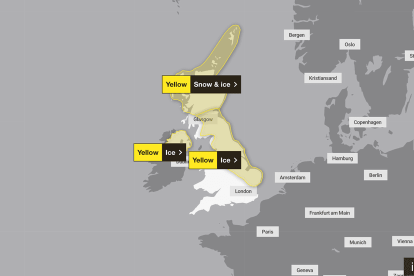
Fresh snow and ice warnings have been issued by the Met Office for extensive areas of the UK. A yellow weather warning is currently active, impacting regions including Central Tayside and Fife, Grampian, Highlands, Orkney and Shetland, and Strathclyde. This alert is set to remain in place until Tuesday morning.
Through Monday afternoon and night, a mix of rain, sleet, and snow is forecast to move southeast across Scotland. These conditions are expected to cause significant travel disruptions, affecting railways, bus, and train services with potentially longer journey times due to icy road surfaces.
Accumulating snow will initially fall on hills, typically above 200 meters, but is expected to descend to lower levels at times. The greatest accumulations are predicted for Monday evening and night, with 1-2 cm possible at low levels, 2-5 cm above 150 meters, and 5-8 cm above 300 meters. Falling temperatures below freezing will also lead to ice formation on untreated surfaces, even where precipitation was initially rain or sleet. Isolated lightning strikes are an additional hazard.
Strong north to northwesterly winds are also anticipated across the Northern Isles and northeastern mainland areas during Monday evening and night, with gusts potentially reaching 50-60 mph in exposed locations. Further yellow weather warnings for ice have been issued for Northern Ireland and several regions in England, including the East Midlands, East of England, North East England, North West England, and Yorkshire and Humber. The Met Office advises drivers to plan their routes, allow extra travel time, and check for any road closures or public transport delays to ensure safety during these wintry conditions.