Home / Weather / UK Faces Freezing Rain and Snow Warnings
UK Faces Freezing Rain and Snow Warnings
3 Feb
Summary
- Freezing rain is forming as supercooled droplets freeze on impact.
- A blocking high-pressure system influences UK weather patterns.
- Snowfall is possible in northern England and Scotland.

WXCharts.com maps show orange indicating areas affected by a rare freezing rain event impacting parts of the country. The Met Office's long-range forecast, spanning February 7 to February 16, predicts that Atlantic frontal systems will approach the UK.
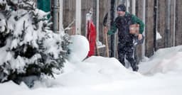
However, these systems are expected to stall due to a blocking area of high pressure located to the north and northeast. This meteorological setup suggests continued rainfall in flood-prone regions. Colder air meeting these rain bands could bring snow, primarily to higher elevations in northern England and Scotland.
Freezing rain develops when precipitation, initially snow or ice, melts into liquid droplets in air above 0°C. As these droplets descend through sub-zero air near the ground, they become supercooled. Upon striking surfaces at or below freezing temperatures, these droplets instantly freeze, creating a smooth glaze of ice.