Home / Weather / Tropical Storm Jerry Spares U.S. Mainland, Heads for Caribbean
Tropical Storm Jerry Spares U.S. Mainland, Heads for Caribbean
8 Oct, 2025
Summary
- Tropical Storm Jerry spinning in Atlantic, 900 miles from Leeward Islands
- Expected to pass near Caribbean islands as a hurricane, but not impact U.S.
- Potential for heavy rain, gusty winds, and localized flooding in the islands

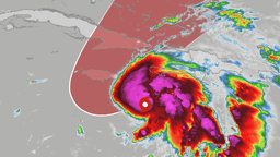
As of October 8th, 2025, Tropical Storm Jerry is still spinning in the Atlantic Ocean, approximately 900 miles from the northern Leeward Islands of the Caribbean. Although the system is expected to strengthen into a hurricane and pass close to several Caribbean islands this week, it will not pose a problem for the U.S. mainland.
A strong cold front diving across the eastern part of the country is forecast to push Jerry out to sea, preventing it from making landfall on the U.S. coast. However, the islands of the northern Leeward chain, including Antigua, Barbuda, Anguilla, and others, are under tropical storm watches as Jerry approaches.
Forecasters predict that Jerry could bring 1 to 4 inches of rain to the affected islands, leading to localized flash flooding and travel disruptions. Gusty winds in the range of 40 to 60 mph are also expected to accompany the storm's closest approach. While Puerto Rico and the U.S. Virgin Islands may see some peripheral effects, such as trailing showers or squalls, the main impacts will be felt in the northern Leeward Islands.
After leaving the Caribbean, the majority of weather models indicate that Jerry will remain east of Bermuda, posing no direct threat to the U.S. mainland. The intensity forecast for the storm remains uncertain, with the potential for it to range from a tropical storm to a major hurricane in the days ahead.