Home / Weather / Rare Fujiwhara Effect Pulls Hurricane Imelda Away from US Landfall
Rare Fujiwhara Effect Pulls Hurricane Imelda Away from US Landfall
30 Sep, 2025
Summary
- Hurricane Imelda reached Category 1 status off Florida coast
- Fujiwhara Effect caused larger Hurricane Humberto to pull Imelda away
- Coastal areas still face high risk of heavy rain and wind through October
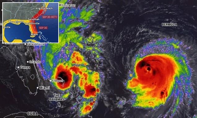
As of September 30, 2025, a rare weather event has unfolded off the East Coast of the United States, with two hurricanes, Imelda and Humberto, interacting in a way that has spared several states from a potentially devastating direct hit.
Just this morning, the National Hurricane Center (NHC) declared that Tropical Storm Imelda had rapidly intensified into a Category 1 hurricane, with sustained winds exceeding 75 mph. Imelda had been on a path to potentially make landfall in Florida, Georgia, or the Carolinas, raising concerns about the threat of flooding and destruction.
However, meteorologists have now reported that the much larger Hurricane Humberto, situated roughly 500 miles away in the Atlantic, has begun to influence Imelda's trajectory through a rare weather phenomenon known as the Fujiwhara Effect. This interaction between the two storms has caused Imelda to veer away from the Southeast, with forecasts now showing it making a sharp turn east towards Bermuda.
Experts have hailed this as a historic event, with one meteorologist stating that "this will be one of the only times in history that a HURRICANE has prevented another HURRICANE from striking the US." The Fujiwhara Effect, which occurs when two tropical cyclones get close enough to influence each other's path and strength, is a relatively rare occurrence during the Atlantic hurricane season.
While the immediate threat from Imelda has been averted, forecasters have warned that coastal areas from Florida to Virginia still face a high risk of tropical wind and rain over the next two weeks. Rough surf, rip currents, and coastal flooding remain a concern through the weekend. Additionally, meteorologists have cautioned that the 2025 hurricane season is not over, with the potential for a couple more storms to develop in the coming weeks.


