Home / Weather / Atmospheric River to Bring Flooding Rains, Heavy Snowfall to Pacific Northwest
Atmospheric River to Bring Flooding Rains, Heavy Snowfall to Pacific Northwest
19 Oct, 2025
Summary
- Series of storms to impact Pacific Northwest later this week
- Threat of flooding rainfall, mountain snowfall, and travel disruptions
- Atmospheric River pattern to bring heavy rain and potential flooding

According to the latest weather forecast, the Pacific Northwest is bracing for a series of potent storms that will impact the region later this week. Beginning on Wednesday, a storm system originating from western Canada will advance into parts of southwest British Columbia, Washington, and northern Oregon, bringing occasional showers and blustery conditions.
This will be followed by an even more powerful storm on Thursday, which is expected to bring drenching rainfall and heavy snow across the higher terrain. Wind gusts associated with this storm could reach upwards of 50 mph over the ocean and immediate coastal areas, with 30-40 mph gusts farther inland.
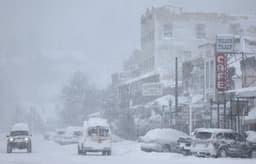
Meteorologists warn that this late-week pattern is indicative of an Atmospheric River, a phenomenon that typically yields heavy rain and flooding, with only very high-elevation snow in the mountains. Coastal regions in Washington and Oregon are projected to receive 2-4 inches of rain, with localized pockets of around 6 inches possible, particularly in areas that see repeated downpours.
The heavy rainfall and strong winds are expected to cause travel disruptions and potential flooding across the region. Additionally, a heavy, wet snow is forecast to fall in the highest crests of the Cascades and Sierra Nevada mountains, likely impacting major roadways and passes.
This stormy pattern is expected to continue into the weekend, gradually helping to alleviate the severe and extreme drought conditions affecting parts of the Northwest and Northern California. However, the heavy precipitation will come at a cost, with the potential for flooding and other hazardous conditions.