Home / Weather / Powerful Storm System Brings Heavy Rain, Snow, and High Winds to Western Washington
Powerful Storm System Brings Heavy Rain, Snow, and High Winds to Western Washington
24 Oct
Summary
- Moderate to heavy rain forecast for South Sound through the weekend
- Cascades and Olympic mountains to see moderate to heavy snow
- Temperatures expected to drop with highs in the upper 40s
- Region experiencing a rainfall deficit, hoping for relief from the storm

As of October 24th, 2025, a powerful storm system is poised to sweep through Western Washington, bringing a mix of heavy rain, snow, and high winds to the region. According to the Seattle National Weather Service, the South Sound area, including Tacoma and Olympia, is forecast to see moderate to heavy rainfall continuing from Thursday night into Friday and throughout the weekend.
The storm is expected to deliver around 0.5 to 1 inch of rain to the South Sound, accompanied by strong windy conditions, particularly along the coast. Gusts are predicted to reach 20 to 25 miles per hour, with the potential to exceed 30 miles per hour in some areas.
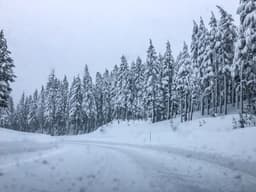
For those in the higher elevations, the forecast is even more wintry. Moderate to heavy snow is expected to hit the Cascades and Olympic mountain ranges, with snow levels falling between 2,500 and 3,500 feet. As the rain sets in on Friday, temperatures are expected to drop slightly, with highs in the upper 40s continuing into the following week.
The unsettled weather patterns are not unusual for this time of year, according to Dev McMillian, a meteorologist at the NWS Seattle. However, what is atypical is the region's rainfall deficit. This year has been the 7th driest January through August on record in Washington, with total precipitation falling 6.22 inches below normal. Residents are hopeful that the upcoming stormy conditions will help alleviate the drought-like conditions.