feedzop-word-mark-logo
searchLogin
Feedzop
homeFor YouUnited StatesUnited States
You
bookmarksYour BookmarkshashtagYour Topics
Trending
Terms of UsePrivacy PolicyAboutJobsPartner With Us

© 2026 Advergame Technologies Pvt. Ltd. ("ATPL"). Gamezop ® & Quizzop ® are registered trademarks of ATPL.

Gamezop is a plug-and-play gaming platform that any app or website can integrate to bring casual gaming for its users. Gamezop also operates Quizzop, a quizzing platform, that digital products can add as a trivia section.

Over 5,000 products from more than 70 countries have integrated Gamezop and Quizzop. These include Amazon, Samsung Internet, Snap, Tata Play, AccuWeather, Paytm, Gulf News, and Branch.

Games and trivia increase user engagement significantly within all kinds of apps and websites, besides opening a new stream of advertising revenue. Gamezop and Quizzop take 30 minutes to integrate and can be used for free: both by the products integrating them and end users

Increase ad revenue and engagement on your app / website with games, quizzes, astrology, and cricket content. Visit: business.gamezop.com

Property Code: 5571

Home / Weather / Philly Braces for Snow Squalls & Deep Freeze

Philly Braces for Snow Squalls & Deep Freeze

6 Feb

•

Summary

  • Light snow expected Friday night, with potential for dangerous travel.
  • Snow squalls with white-out conditions and icy roads are possible.
  • Extreme cold and high winds forecast from Saturday through Monday.
Philly Braces for Snow Squalls & Deep Freeze

Light snow is expected to begin Friday evening and continue into the overnight hours across southeastern Pennsylvania and parts of New Jersey, according to the National Weather Service. While amounts are predicted to be less than an inch in most affected counties, the potential for snow squalls early Saturday morning raises concerns for dangerous travel. These quick-hitting storms can produce white-out conditions and icy roads due to rapidly dropping temperatures.

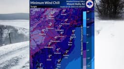
Following the light snow, an arctic front will usher in a significant cold snap. An extreme cold watch has been issued by the NWS, running from Saturday afternoon through Sunday morning. Residents can expect high winds, with gusts potentially reaching 40 to 60 mph. Sustained winds are forecast between 20 and 35 mph. This combination of wind and frigid temperatures could lead to dangerous wind chills, as low as -25 degrees in northern areas, lasting at least through Monday morning.

Disclaimer: This story has been auto-aggregated and auto-summarised by a computer program. This story has not been edited or created by the Feedzop team.
Light snow is expected to begin Friday evening and continue into the overnight hours, with amounts generally less than an inch.
Snow squalls are quick-hitting storms with white-out conditions that can cause icy roads, and they are possible early Saturday morning.
An extreme cold watch is in effect from Saturday afternoon through Monday morning, bringing high winds and wind chills as low as -25 degrees.

Read more news on

Weatherside-arrowPennsylvaniaside-arrow
trending

PFC REC merger approved

trending

Tata Steel share price surges

trending

ITC stock market stability

trending

SBI share price jumps

trending

ITA Airways promotes Olympics

trending

Brandon McMullen scores 41

trending

Scotland seek Italy revenge

trending

Zimbabwe vs Oman T20

trending

Kruthik Krishna proves mettle

You may also like

Record Cold Grips New Jersey This Week

26 Jan • 79 reads

article image

Pittsburgh Schools Close Amid Winter Storm

22 Jan • 139 reads

article image

Northeast Snow Chaos: 1,500 Flights Grounded

28 Dec, 2025 • 287 reads

article image

Snow Alert: 5 Inches Possible This Weekend!

14 Dec, 2025 • 361 reads

article image

Freezing Rain Threatens Travel for 1 Million in Northeast This Weekend

14 Nov, 2025 • 529 reads

article image