Home / Weather / Ontario Gripped by Blizzard: Travel Chaos Ensues
Ontario Gripped by Blizzard: Travel Chaos Ensues
19 Jan
Summary
- Blizzard warnings and snow squalls create hazardous travel conditions.
- Expect up to 40 cm of snowfall in harder-hit regions.
- Frigid Arctic air will bring dangerously cold temperatures by the weekend.
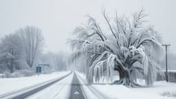
A significant winter weather event is currently impacting Ontario, bringing blizzard conditions and heavy snow squalls to many areas. Strong winds reaching up to 90 km/h are causing reduced visibility, leading to hazardous travel conditions and potential road closures. Some locations are bracing for snowfall amounts between 20-40 cm by Tuesday.
Areas along Highway 401, Prince Edward County, and the snowbelts off Lake Huron and Georgian Bay are particularly affected by intense snow squalls and blowing snow. Warnings are in effect for the north shore of Lake Erie as well. These conditions are expected to persist, with additional snowfall anticipated mid-week in the Greater Toronto Area.
Looking ahead to the weekend, a shift to frigid Arctic air is predicted across Ontario. Daytime highs are expected to remain well below seasonal averages throughout January, with overnight lows in Ottawa potentially reaching -21°C. Northern Ontario faces the most extreme cold, with temperatures possibly dipping to -40°C.