Home / Weather / Ohio Valley braces for severe storms, flash floods
Ohio Valley braces for severe storms, flash floods
21 Jul
Summary
- Thunderstorms bring damaging winds, hail, and flash floods.
- An isolated tornado threat remains for the Ohio Valley.
- Flood Watch in effect for parts of Kentucky and Ohio.
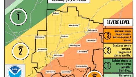
Severe thunderstorms are poised to impact the Ohio Valley on Tuesday, July 21, with multiple rounds of storms expected. A Flood Watch has been issued for southeastern portions of Northern Kentucky and Ohio, including counties like Grant in Kentucky and Brown and Adams in Ohio. Residents are warned of the potential for damaging winds, large hail, and localized flash flooding.
The first wave of storms is anticipated during the morning hours, with a possibility of strengthening by late morning, primarily south of I-71. Forecasters indicate that the atmosphere may recover sufficiently in the afternoon to support another round of severe weather. Repeated rainfall could total 1 to 3 inches, with isolated higher amounts, though progressive rain movement is expected to limit widespread flash flooding. However, localized flash flooding remains a concern, especially in southeastern areas where storm coverage is expected to be at its peak.
While damaging winds are the primary concern, the possibility of large hail and an isolated tornado cannot be ruled out. Looking ahead, the weather forecast for Cincinnati includes showers and thunderstorms on Tuesday, with a high near 88 degrees. Wednesday and Thursday are expected to be mostly sunny and cooler, with highs near 79 degrees.


