Home / Weather / End of Cold Spell Brings Flood Risk to Northern Ireland
End of Cold Spell Brings Flood Risk to Northern Ireland
10 Jan
Summary
- Heavy rain and strong winds expected across Northern Ireland.
- Temperatures to rise significantly, increasing flood potential.
- Friday night saw the coldest temperatures of the winter at -7C.

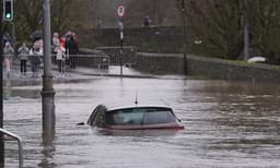
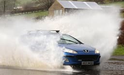
Northern Ireland faces a severe weather alert for heavy rain and strong winds commencing Saturday night and continuing through Sunday. Met Office warnings indicate a significant shift from the recent cold spell, which saw temperatures drop to -7C on Friday night, the coldest of the winter so far. Milder conditions are expected, leading to snowmelt and an increased risk of flooding.
The rainfall could reach 20-30mm rapidly, with up to 60mm possible in higher elevations. Simultaneously, south to southwesterly winds will bring gusts of 70-100km/h widely, potentially reaching 130km/h in exposed coastal areas. These winds are predicted to worsen the impact of heavy rainfall, with gale-force conditions likely along coasts.
Meanwhile, the Republic of Ireland's coastline is also under wind warnings due to strong, gusty winds and the potential for large coastal waves and travel disruptions. This transition follows a period of extreme cold, with rare ice pancakes observed on a river in County Tyrone.