Home / Weather / Isaias Remnants Threaten Memphis with Wind and Rain
Isaias Remnants Threaten Memphis with Wind and Rain
10 Oct
Summary
- Remnants of Hurricane Isaias will bring strong winds up to 40 mph to the Mid-South.
- A Flood Watch is in effect, with potential for heavy rainfall and flash floods.
- The storm is expected to bring cooler temperatures to the region.
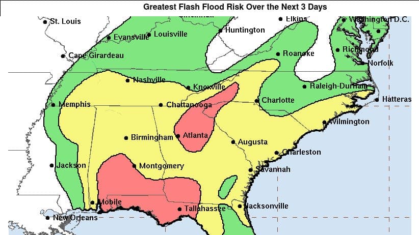
The Mid-South region, including Memphis, is preparing for the impact of the remnants of Hurricane Isaias this week. While the area is not in the storm's direct path, the National Weather Service forecasts wind gusts up to 40 mph and periods of heavy rainfall, beginning on October 10. A Flood Watch has been issued from early October 10 to early October 11, with the possibility of flash flood warnings depending on rainfall intensity.
Residents can expect conditions to worsen on October 10, with a 100% chance of rain in the afternoon and wind gusts potentially reaching 40 mph. Rainfall amounts could range from 1 to 3 inches. Temperatures are also expected to drop, with a high of 65 degrees and an evening low of 61 degrees. The heavy rainfall is predicted to subside by early October 11, after which a warmer weather pattern is expected for the Mid-South.
It is important to understand the difference between a storm watch and a warning. A watch indicates an increased risk of hazardous weather, urging preparation, while a warning signifies that hazardous weather is imminent or occurring, requiring immediate protective action for life and property.


