feedzop-word-mark-logo
searchLogin
Feedzop
homeFor YouUnited StatesUnited States
You
bookmarksYour BookmarkshashtagYour Topics
Trending
Terms of UsePrivacy PolicyAboutJobsPartner With Us

© 2026 Advergame Technologies Pvt. Ltd. ("ATPL"). Gamezop ® & Quizzop ® are registered trademarks of ATPL.

Gamezop is a plug-and-play gaming platform that any app or website can integrate to bring casual gaming for its users. Gamezop also operates Quizzop, a quizzing platform, that digital products can add as a trivia section.

Over 5,000 products from more than 70 countries have integrated Gamezop and Quizzop. These include Amazon, Samsung Internet, Snap, Tata Play, AccuWeather, Paytm, Gulf News, and Branch.

Games and trivia increase user engagement significantly within all kinds of apps and websites, besides opening a new stream of advertising revenue. Gamezop and Quizzop take 30 minutes to integrate and can be used for free: both by the products integrating them and end users

Increase ad revenue and engagement on your app / website with games, quizzes, astrology, and cricket content. Visit: business.gamezop.com

Property Code: 5571

Home / Weather / Cincinnati Braces for Snow Barrage: Advisory, Then Storm Watch

Cincinnati Braces for Snow Barrage: Advisory, Then Storm Watch

13 Dec, 2025

•

Summary

  • Winter weather advisory active until Friday morning with 1-2 inches of snow.
  • Northern Kentucky counties are under a Level 1 Snow Emergency.
  • A significant winter storm watch is in effect Saturday to Sunday.
Cincinnati Braces for Snow Barrage: Advisory, Then Storm Watch

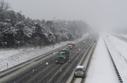
A winter weather advisory is in effect for the Cincinnati region, bringing early morning snow. Accumulations are expected to be between 1 to 2 inches, leading to some school closures and delays. The National Weather Service warns that travel may be difficult during this period.

In response to the hazardous conditions, Boone, Kenton, and Campbell counties in Northern Kentucky have implemented a Level 1 Snow Emergency. This designation advises drivers to proceed with caution and consult with employers regarding work attendance.

Looking beyond Friday's snowfall, a more significant weather event is anticipated. A winter storm watch has been issued for Saturday morning through Sunday morning, with forecasts indicating the potential for 3 to 5 inches of heavy snow. Following the snow, bitterly cold wind chills are expected to impact the area on Sunday and Monday.

trending

Jerusalem daycare babies dead

trending

Apple TV service disruption

trending

Mets acquire Luis Robert Jr.

trending

Severe geomagnetic storm alert

trending

Carlos Beltran Hall of Fame

trending

Mike McDaniel joins Chargers

trending

Texas winter storm watch

trending

Punta Cana tourism surge

trending

Miami Ohio basketball improves to 20-0

Disclaimer: This story has been auto-aggregated and auto-summarised by a computer program. This story has not been edited or created by the Feedzop team.
A winter weather advisory is active until Friday morning, with 1 to 2 inches of snow expected. Some schools have closures or delays.
Yes, Boone, Kenton, and Campbell counties in Northern Kentucky are on a Level 1 Snow Emergency due to hazardous road conditions.
A winter storm watch is in effect from Saturday to Sunday, with predictions of 3 to 5 inches of heavy snow possible.

Read more news on

Weatherside-arrow

You may also like

Arctic Blast Hits Pittsburgh: Frostbite Danger Looms

19 hours ago • 10 reads

article image

Sudden Snow Squall Threatens Tri-State Area Roads

1 Jan • 89 reads

article image

Coshocton Sees Below-Average Temps, Flurries Ahead

1 Jan • 110 reads

article image

Idaho Faces Extreme Thunderstorms: 80 MPH Winds Threaten!

18 Dec, 2025 • 213 reads

article image

Dangerous Winds of 75 MPH to Hit Northern CA

16 Dec, 2025 • 219 reads

article image