Home / Weather / Arizona Braces for More Thunderstorms, Flood Watch Issued
Arizona Braces for More Thunderstorms, Flood Watch Issued
21 Nov
Summary
- Severe thunderstorm warning issued for Peoria, Glendale, Tolleson, and Phoenix areas.
- Flood watch in effect for northern Maricopa and parts of Yavapai counties due to saturated ground.
- Temperatures to remain in the mid-60s before warming next week with drier conditions.

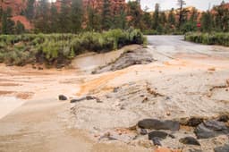
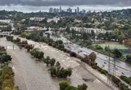
The West Valley is bracing for additional rainfall on Wednesday, as the National Weather Service has issued a severe thunderstorm warning for the region. This alert covers cities such as Peoria, Glendale, Tolleson, and Phoenix, and is expected to last until 5:30 p.m. The prior day's rain has saturated the ground, increasing the likelihood of flooding with any further precipitation.
A flood watch has been implemented for northern Maricopa County and portions of Yavapai County, affecting areas like Prescott and Camp Verde. These regions could experience flooding from heavy thunderstorm rainfall. The forecast indicates temperatures will stay in the mid-60s for the next few days, with a return to the 70s expected next week under drier conditions.
For higher elevations, snow levels are predicted to drop to around 6500 feet through Thursday, with 1-2 inches of snow possible in Flagstaff. Eastern Arizona's Rim and White Mountains may see heavier accumulations. Additional Pacific weather systems are anticipated Thursday night and into Friday, potentially bringing more rain to western Arizona.