Home / Environment / UK Snow Alert: Four Inch Per Hour Flurries Incoming!
UK Snow Alert: Four Inch Per Hour Flurries Incoming!
16 Jan
Summary
- Scattered snow expected to hit the UK starting January 23rd.
- Scotland and South Wales could see four inches of snow hourly.
- Snow accumulation varies, with highlands seeing the most.
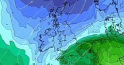
Snowfall is anticipated across the UK starting January 23rd, with initial flurries expected in Northern Ireland, Wales, northern England, and Scotland. The most intense snowfall, potentially reaching four inches per hour, is predicted for Scotland. Weather models indicate scattered snow showers will continue for five days, with southern England and Wales also facing potential impacts.
By January 26th, heavy snow is forecast to concentrate in Scotland and South Wales, with rates up to four inches per hour. Southern England, including Brighton, may also see significant snowfall on January 27th. While the wintry blast is widespread, snow accumulations are generally expected to be modest, except for the Scottish Highlands which could see up to 32cm.
The Met Office forecasts a potential shift to colder weather later in January, increasing the chance of snow across the country. This follows Storm Goretti earlier this month, which brought severe winds and substantial snow, leading to a red weather warning.