feedzop-word-mark-logo
searchLogin
Feedzop
homeFor YouUnited StatesUnited States
You
bookmarksYour BookmarkshashtagYour Topics
Trending
trending

Harry Kane guides Bayern victory

trending

Michigan defeats Washington football

trending

Arsenal tops Premier League

trending

Atletico Madrid vs Osasuna

trending

Giants to hire Tony Vitello

trending

F1 United States qualifying

trending

Florida beats Mississippi State

trending

Ohio State faces Wisconsin

trending

Georgia football vs Ole Miss

Terms of UsePrivacy PolicyAboutJobsPartner With Us

© 2025 Advergame Technologies Pvt. Ltd. ("ATPL"). Gamezop ® & Quizzop ® are registered trademarks of ATPL.

Gamezop is a plug-and-play gaming platform that any app or website can integrate to bring casual gaming for its users. Gamezop also operates Quizzop, a quizzing platform, that digital products can add as a trivia section.

Over 5,000 products from more than 70 countries have integrated Gamezop and Quizzop. These include Amazon, Samsung Internet, Snap, Tata Play, AccuWeather, Paytm, Gulf News, and Branch.

Games and trivia increase user engagement significantly within all kinds of apps and websites, besides opening a new stream of advertising revenue. Gamezop and Quizzop take 30 minutes to integrate and can be used for free: both by the products integrating them and end users

Increase ad revenue and engagement on your app / website with games, quizzes, astrology, and cricket content. Visit: business.gamezop.com

Property Code: 5571

Home / Environment / Hikers Witness Jasper's Rebirth Through Innovative Photo Monitoring

Hikers Witness Jasper's Rebirth Through Innovative Photo Monitoring

5 Oct

•

Summary

  • Jasper wildfire in 2024 drastically changed landscape
  • Parks Canada and University of Waterloo launch citizen science project
  • Hikers can upload photos to track post-fire regrowth
Hikers Witness Jasper's Rebirth Through Innovative Photo Monitoring

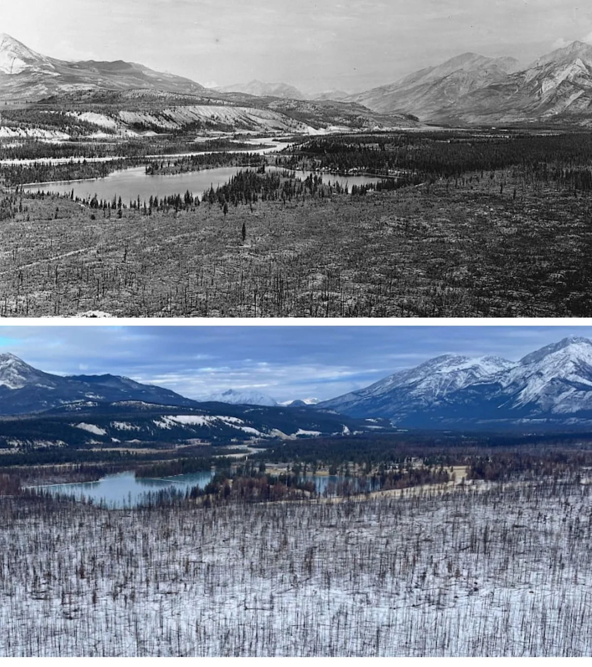
As of October 2025, visitors to Old Fort Point in Jasper National Park are witnessing a dramatic transformation of the landscape following the devastating wildfire that swept through the area in July 2024. The once-lush forest has been replaced by a mosaic of charred patches, a sight that now bears a striking resemblance to photos taken in the early 1900s.

However, the landscape is slowly but surely beginning to regenerate, and Parks Canada has teamed up with the University of Waterloo to engage the public in this process. Through a citizen science project, hikers on the popular 3.8-kilometer Old Fort Point trail can now capture and upload photos to help researchers track the area's rebirth.

The project, known as GeoReach, uses standardized imagery data to monitor changes in various landforms across Canada, including post-forest fire regrowth. Visitors can take photos from designated stations along the trail and directly upload them to the GeoReach website, contributing to a growing gallery that showcases the transformation.

"It gives a really good opportunity for visitors and everyday people to just connect with the landscape and to connect with that process of ecological integrity monitoring and citizen science," said Kevin Gedling, a Parks Canada communications and engagement officer.

The early signs of regeneration are already visible, with vibrant grass, purple fleabane, and yellow arnica emerging from the charred soil. Fireweed, a plant that thrives in nutrient-rich post-fire environments, is also beginning to appear, and Gedling expects it to flourish in the coming years.

While the Jasper wildfire complex caused significant damage, destroying one-third of the townsite's structures and displacing 2,000 people, Gedling acknowledges that such events are a natural part of the forest's life cycle. "As far as a natural process is concerned, this is literally one of the better things that can happen to it," he said.

Disclaimer: This story has been auto-aggregated and auto-summarised by a computer program. This story has not been edited or created by the Feedzop team.
The Jasper citizen science project, launched by Parks Canada and the University of Waterloo, allows hikers on the Old Fort Point trail to capture and upload photos to track the regeneration of the landscape after the 2024 Jasper wildfire.
Visitors can participate by taking photos from designated stations along the Old Fort Point trail and uploading them to the GeoReach website, a University of Waterloo initiative that monitors changes in landforms across Canada.
According to the article, the Jasper landscape is already showing signs of regrowth, with vibrant grass, purple fleabane, yellow arnica, and fireweed emerging from the charred soil. Aspen "suckers" are also regenerating using the existing root systems.

Read more news on

Environmentside-arrow

Advertisement

Advertisement

Advertisement

You may also like

Melting Arctic Ice Transforms Shipping Lanes, Threatens Ecosystems

15 Oct • 12 reads

article image

Coffey Park Rises from Ashes: Santa Rosa Neighborhood Rebuilds After Devastating Wildfire

9 Oct • 34 reads

article image

Dymchurch Beach Loses Blue Flag Status Amid Water Quality Concerns

10 Oct • 33 reads

article image

Innovative Sand Spread Saves Sinking Salt Marsh in Maine

8 Oct • 51 reads

article image

Centuries-Old Forest Reduced to Ashes: Teakettle Experimental Forest Devastated by Wildfire

5 Oct • 47 reads