Home / Environment / Record Ocean Heat Signals Super El Niño
Record Ocean Heat Signals Super El Niño
10 Jul
Summary
- El Niño may become one of the strongest on record, impacting global weather.
- Central equatorial Pacific ocean temperatures are record warm, forecast to rise.
- This El Niño could lead to unprecedented global temperatures and weather shifts.
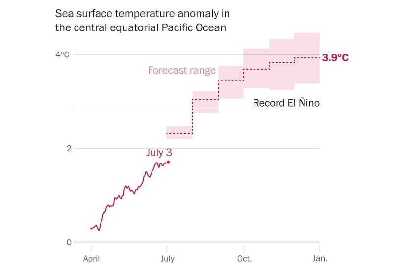
An anticipated El Niño, which formed this past summer, is developing into one of the strongest events on record. Data from early July revealed that ocean temperatures in the central equatorial Pacific have been exceptionally warm for about a month. Forecasts indicate these temperatures will continue on a record-breaking trajectory through December, potentially peaking around 3.9 degrees Celsius (7.0 degrees Fahrenheit) above average.
This extraordinary warming in the Pacific Ocean is expected to drive significant global weather impacts, potentially stronger and more prolonged than previous events. Global temperatures may reach new highs, accompanied by shifts in drought, flood, heat, and humidity patterns worldwide. The current El Niño's intensity is projected to surpass historical records, including notable events in 1877-78, 1997-98, and 2015-16.
El Niño is a natural phenomenon involving the warming of Pacific Ocean waters every two to seven years. These warmer seas alter thunderstorm patterns, which in turn influence global weather through changes in the jet streams. The current El Niño was initiated by a wind burst in December and sustained by oceanic waves moving warm water from west to east.
This year's El Niño phase is expected to significantly elevate global temperatures, with an over 80 percent chance that 2027 becomes the warmest year on record. Through September, approximately 2.8 billion people face a 10 percent chance of experiencing record-high temperatures for the time of year. Additionally, around 1.4 billion people are in areas with a higher risk of drought, while 757 million face a risk of excessive precipitation and potential flooding.
Scientists use a new climate change-adjusted index to differentiate El Niño's warming from long-term background ocean warming. The latest forecasts suggest a gap of around 0.55 degrees Celsius (1.0 degree Fahrenheit) between the traditional El Niño index and this new relative index during the expected peak in December. This additional background warming can amplify precipitation extremes globally, as warmer air holds more moisture.


