Home / Weather / Washington's Winter Woes: Snow, Ice, and Flooding Ahead
Washington's Winter Woes: Snow, Ice, and Flooding Ahead
14 Mar
Summary
- Cascade foothills expecting up to 2 feet of wet snow.
- Pass travel in Cascades will be difficult to impossible.
- Minor river flooding expected on multiple rivers Saturday.

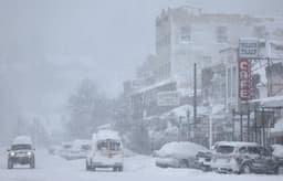
A wintry mix of rain and snow is impacting much of Washington. The Cascade foothills are under a Winter Weather Advisory, with predictions of an additional 1-2 feet of wet snow accumulation continuing into the late evening. This accumulation may persist on roads as temperatures fall.
Elsewhere, precipitation is expected to taper from north to south into the early evening, with most major roads remaining wet. Overnight, temperatures near freezing could cause patchy ice in rural areas, though most pavement will be wet or slushy.
In the Cascades, a Winter Storm Warning remains in effect through Saturday morning, forecasting an additional 6-10 inches of snow. Travel over mountain passes is expected to be extremely difficult, with a high risk of avalanches. Light snow showers might reappear near the Cascades on Saturday morning, with some sunshine expected by afternoon.
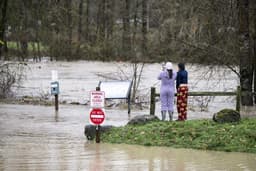
Saturday will also see minor flooding on the Skokomish, Chehalis, Skookumchuck, and Newaukum rivers. Rain showers are forecast to return Sunday afternoon and evening, primarily in the northern areas. Significantly warmer temperatures are predicted for the start of next week, with highs in Seattle reaching the mid to upper 50s.