Home / Weather / UK Faces Blizzard Alert: Snow and -9C Cold Snap Arrives
UK Faces Blizzard Alert: Snow and -9C Cold Snap Arrives
26 Mar
Summary
- Britain is expecting blizzards and temperatures as low as -9C this week.
- Snowfall is predicted to reach as far south as Berkshire and Hampshire.
- This cold snap follows a week where temperatures exceeded 20C in west Wales.

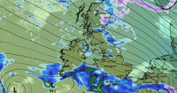
A harsh cold snap is set to affect the UK this week, with forecasters predicting blizzards and plummeting temperatures. Data indicates a low-pressure system moving in from the North Atlantic will bring snow and icy conditions across much of Britain, including northern Scotland, the North West of England, the Midlands, Wales, and Southern England. Temperatures are expected to drop as low as -9C, with snow reaching areas as far south as Berkshire and Hampshire.
This severe weather represents a stark contrast to the mild conditions experienced last week, when temperatures in west Wales exceeded 20C. The cold weather is predicted to be most intense on Saturday and Sunday, though the cold snap began earlier in the week. The Met Office has warned of rain, sleet, and hail showers, with snow likely over higher ground in the north. Wind chill will make temperatures feel significantly colder, potentially reaching -5C in rural Scotland overnight, with widespread frost and icy patches expected.
Looking ahead, unsettled weather with rain and strong winds is expected to continue until the end of the month. The coming days will see a series of weather fronts bringing much colder air. While some areas may experience a brief milder spell by the end of the week, further rain and windy conditions are forecast for Sunday.