Home / Weather / UK Chills: Arctic Blast Brings Snow and Ice Warnings
UK Chills: Arctic Blast Brings Snow and Ice Warnings
3 Jan
Summary
- Temperatures dropped to -5.7C in the Scottish Highlands.
- Up to 40cm of snow expected on higher ground in amber zones.
- Rail, air travel, and roads may face delays and cancellations.
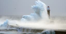
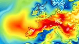
Arctic air and strong northerly winds are dominating the UK as the new year begins, bringing a significant chill and warnings of snow and ice for many regions. Temperatures have already dropped sharply, reaching -5.7C in Drumnadrochit, located on the shores of Loch Ness in the Scottish Highlands. This cold snap is expected to continue throughout the weekend and into next week, with daytime highs struggling to rise above freezing in some inland areas and overnight lows potentially reaching double digits below zero.
Forecasters have issued yellow and amber warnings for snow and ice, predicting heavy snow showers, particularly in northern Scotland and over elevated terrain elsewhere. Some rural communities could become isolated, and accumulations of up to 40cm of snow are forecast for areas under the amber alert. These conditions are likely to cause disruptions, with potential delays and cancellations to rail and air services, as well as hazardous driving conditions on roads due to icy surfaces.
The Met Office advises the public to remain weather-aware, stay updated with the latest forecasts, and plan their journeys accordingly. Bitterly cold conditions are expected to persist, with daytime temperatures remaining low and the risk of icy roads and slippery surfaces throughout the period. The public is urged to take precautions against the cold and potential travel disruptions.