Home / Weather / UK Braces for Sunday Snow and Ice Fury
UK Braces for Sunday Snow and Ice Fury
10 Jan
Summary
- Yellow snow and ice warning issued for Sunday across northern England and Scotland.
- Disruption expected, including travel delays and potential power cuts.
- Up to 30cm of snow possible in higher Scottish regions; ice widespread.
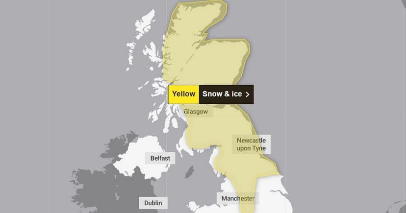
Following the significant impact of Storm Goretti, the UK is now under a new yellow warning for snow and ice, valid from 2am to 3pm on Sunday. This alert covers northern England and Scotland, with forecasters predicting a spell of snow that could cause considerable disruption. Travel by road, rail, and air may experience delays or cancellations, and stranded vehicles are a possibility. The risk of injuries from slips and falls on icy surfaces is also highlighted, alongside the potential for power cuts.
Forecasters anticipate that snow accumulation will vary by elevation and precipitation intensity. While most of northern England may see snow above 200 metres, lower levels in Scotland could experience snowfall, especially in the morning. Accumulations of 2-5cm are likely at lower levels, potentially reaching 10cm locally. Higher ground in Scotland and exposed hills could see 10-20cm, with up to 30cm in the highest areas. Strong winds are expected to cause snow drifting, and icy conditions are predicted widely.
This warning follows a weekend of unsettled weather, with Storm Goretti having already caused widespread power outages and dangerous wind conditions. Met Office Chief Forecaster Steve Willington noted that Sunday's front from the west would bring snow to Scotland and northern England, continuing the ice risk. Central and southern England and Wales are expected to see rain, making for a wet Sunday across much of the country.