Home / Weather / UK Braces for Snow: Early Winter Flurries Ahead
UK Braces for Snow: Early Winter Flurries Ahead
13 Nov
Summary
- Snowfall is predicted for parts of England, Wales, and Scotland early next week.
- Met Office weather maps indicate snow could be more widespread than initially thought.
- Wintry conditions follow an early major sudden stratospheric warming event.
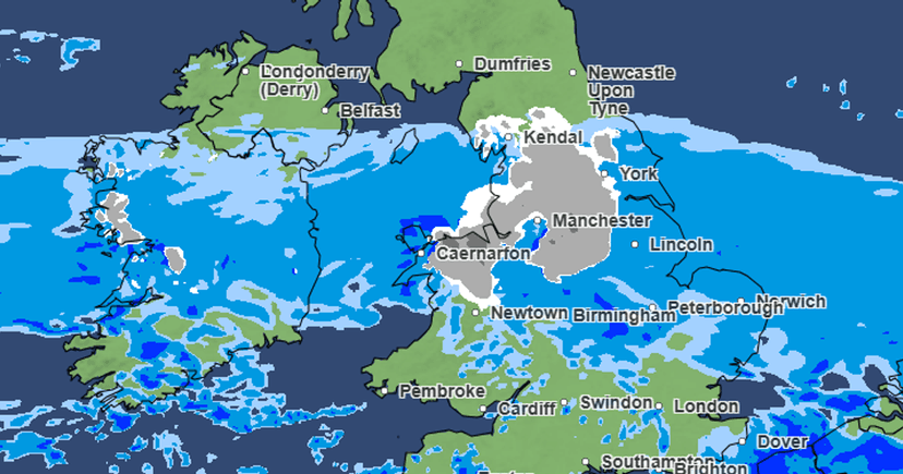
Early next week, parts of England, Wales, and Scotland are forecast to experience snowfall, according to Met Office weather maps. Initial predictions of "hill snow" for Monday and Tuesday may be extended to more widespread flurries than previously anticipated.
Met Office charts suggest snow will first appear in Wales around 6 PM on Monday, particularly over hills in North Wales. By 9 PM, snow is expected to reach parts of Yorkshire and northern Nottinghamshire and Derbyshire. By midnight, snow is projected to cover most of North Wales and northern England, moving towards the Scottish borders by early Tuesday morning.
Prior to Monday, "some rain and hill snow" is forecast for Scotland on Saturday, with largely fine and dry conditions elsewhere. This weather outlook follows the "earliest major sudden stratospheric warming (SSW) on record," an event where Arctic winds shift direction. SSWs can alter atmospheric patterns, potentially leading to cold snaps and increased snowfall in the UK.
However, forecasters note that the current cold snap is linked to developments in the troposphere, the atmosphere's lowest layer, rather than the stratosphere. Several English counties, including Shropshire, Yorkshire, and Cumbria, along with numerous Welsh counties like Caernarfonshire and Flintshire, are listed as facing potential snow.


