Home / Weather / UK Braces for Blizzard: Snow to Hit Friday with -9C Freeze
UK Braces for Blizzard: Snow to Hit Friday with -9C Freeze
11 Feb
Summary
- Snowfall expected across the UK on Friday, with temperatures reaching -9C.
- Heaviest snow anticipated in northern England and along the North Sea coast.
- Risk of travel disruption and potential flooding due to wintry weather.

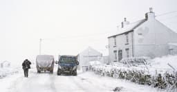
Snow is forecast to blanket large parts of the UK on Friday, accompanied by icy conditions with temperatures potentially dropping to -9C. Weather maps indicate widespread snowfall, with the heaviest accumulations expected across northern England, particularly in Northumberland and along the North Sea coastline. By midday, regions including Yorkshire, the East of England, and North Wales are anticipated to see wintry precipitation.
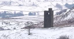
The low-pressure system will move southwards through Friday afternoon, affecting the Midlands and Home Counties. While Saturday is expected to be largely dry and sunny for many, snow showers are possible, especially in the north. A return of heavier snow is predicted for Sunday, with significant accumulations anticipated in the Yorkshire Dales and Scottish Borders.
This forecast raises concerns about exacerbating existing flood risks, as many communities are already dealing with the aftermath of heavy rainfall. Numerous flood warnings remain in effect for rivers like the Severn and Trent in the Midlands, and the River Thames in Berkshire is also a point of concern. A persistent "blocked" weather pattern is contributing to these unsettled conditions.