Home / Weather / Tornado Watch Issued as Severe Storms Threaten Louisiana and Mississippi
Tornado Watch Issued as Severe Storms Threaten Louisiana and Mississippi
26 Oct, 2025
Summary
- Tornado Watch issued for several counties in Louisiana and Mississippi
- Coastal areas under watch, including Lake Pontchartrain and Lake Maurepas
- Possibility of damaging wind gusts, hail, and localized flash flooding

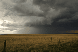
As of October 26th, 2025, the National Weather Service (NWS) has issued a Tornado Watch for several counties in Louisiana and Mississippi. The impacted areas in Louisiana include Jefferson, Washington, St. Bernard, St. Tammany, Plaquemines, and Orleans. In Mississippi, the counties under the Tornado Watch are Pearl River, Hancock, Walthall, Jackson, and Harrison.
Coastal regions such as Lake Pontchartrain, Lake Maurepas, the Mississippi Sound, Lake Borgne, Chandeleur Sound, and Breton Sound are also under the watch. Locals are advised to continuously follow weather updates and be ready to seek refuge without delay if a tornado warning is issued.
The NWS office in Jackson, Mississippi, has warned that isolated severe storms remain a possibility on Sunday morning, primarily across the southeast portion of the region. The primary concern is the potential for damaging wind gusts, but the possibility of a tornado cannot be ruled out. Heavy rain is also expected, which could lead to localized flash flooding, with about 1-2 inches of rain possible in a short period of time.
The storm system is expected to clear up by Sunday afternoon, with the possibility of sunlight breaking through before the end of the day. However, a cold front is scheduled to arrive by midweek, bringing cooler temperatures, with daytime highs in the 60s and nighttime lows close to the low 40s on Thursday.