Home / Weather / Texas Braces for Severe Weather
Texas Braces for Severe Weather
3 Mar
Summary
- Severe weather season is increasing through May.
- May is the wettest month with high risk for hail and tornadoes.
- Temperatures will remain 10-15 degrees warmer than average.

Texas is transitioning from a tranquil early March to its severe weather season, which is projected to intensify through May. Current weather patterns, characterized by morning clouds and afternoon sunshine with above-normal temperatures, are expected to shift drastically later this week. An approaching cold front, losing momentum as it enters the state, will interact with atmospheric disturbances from the west.
This atmospheric clash is expected to bring rain and thunderstorms beginning Wednesday, with a higher concentration in North Texas, though South Texas will also see a 30-40% chance of storms. The Storm Prediction Center has placed parts of Texas under a severe weather threat extending through the weekend. Meteorologists note that the combination of moisture and instability means storms could produce heavier rainfall, though model uncertainty remains high.
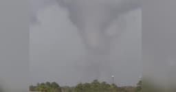
Despite the impending severe weather, temperatures are forecasted to remain significantly warmer than average, running 10 to 15 degrees above the early March high of 70 degrees for the remainder of the week and into the weekend. May is anticipated to be the wettest month, increasing the risk of flash flooding alongside potential hail, damaging winds, and tornadoes.