Home / Weather / Southeast Texas faces new flood risk
Southeast Texas faces new flood risk
2 Oct
Summary
- Rainfall projections have dropped but flooding risk remains.
- Heavy storms expected Thursday, with more tropical downpours possible.
- Temperatures to drop noticeably after Monday/Tuesday front.
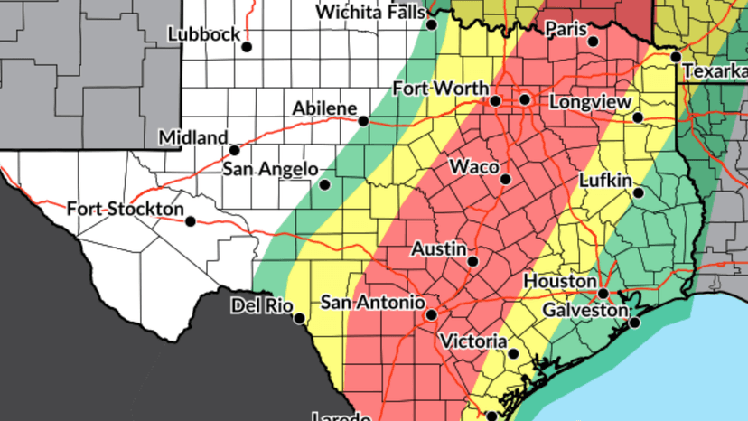
Southeast Texas is preparing for significant rainfall and potential flooding as a line of storms moves through the region. While Houston's overall rainfall projections have decreased, the heaviest rain and greatest flood risk are anticipated northwest of the city through Friday.
A slow-moving system is bringing heavy rain to North and Central Texas, with flood alerts issued from west of San Antonio to the Dallas-Fort Worth area. This system is expected to reach Southeast Texas by Thursday afternoon or evening, with rain continuing overnight and into early Friday, potentially impacting morning commuters.
Rainfall totals are expected to range from 1 to 2 inches in the Brazos Valley and Piney Woods, with about half an inch to 2 inches elsewhere. Stronger storms could drop 2 to 3 inches in a short period, leading to localized street flooding. Creeks and bayous are not anticipated to overflow.
Another period of heavy rainfall is possible late Saturday into Sunday due to moisture gathering along a lingering front and a developing coastal system. Areas south of Interstate 10 could see an additional 1 to 2 inches, bringing total rainfall for the week to 2 to 4 inches. Higher amounts are possible near the coast, though some heavy rain may stay offshore.
A cold front is forecast to move through Southeast Texas around Monday or Tuesday, bringing drier air and a modest drop in temperatures. Houston could experience overnight lows below 70 degrees on several days next week, with rain chances diminishing behind the front.


