Home / Weather / Florida Panhandle Faces Severe Storms: Tornado Risk High
Florida Panhandle Faces Severe Storms: Tornado Risk High
7 May
Summary
- Severe storms bring tornado risk to Florida Panhandle, Georgia, Carolinas.
- Damaging wind gusts are primary threat, with isolated tornadoes possible.
- Mississippi experienced multiple tornadoes and widespread damage.
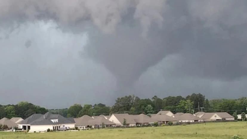
Severe weather systems continued their eastward progression on Thursday, prompting a Level 2 severe weather risk for parts of the Florida Panhandle. Residents across Florida, Georgia, and the Carolinas faced a heightened concern for tornadoes. The foremost threat identified by forecasters was the potential for damaging wind gusts, with isolated tornadoes also a possibility throughout Thursday evening.
This weather system is the same cold front that previously caused destructive storms and flash flooding across the southern United States, from Louisiana to Georgia. As the front began to stall, an increased risk of flash flooding was anticipated in southern Alabama, Mississippi, and southern Georgia due to repeated storm cells crossing the same areas.
Meanwhile, Mississippi was still assessing damage from multiple tornadoes that struck the state earlier in the week. These storms caused significant destruction to homes, downed numerous power lines, and toppled trees. Areas near Hattiesburg were under a Particularly Dangerous Situation, with over 100,000 people in the storm's direct path. Damage assessments and searches were ongoing in several counties.