Home / Weather / Powerful Low-Pressure System to Bring Stormy Weather to UK This Sunday
Powerful Low-Pressure System to Bring Stormy Weather to UK This Sunday
14 Oct, 2025
Summary
- Severe thunderstorms and gales up to 45mph expected across parts of UK
- Heaviest rain and winds to hit Southeast and East of England
- Storm to move northwards over London and impact Essex and Suffolk

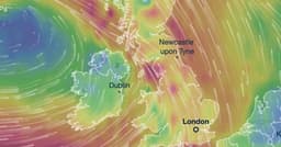
According to the latest weather forecasts, a powerful low-pressure system is poised to sweep across parts of the UK this Sunday, bringing with it a barrage of severe thunderstorms and gale-force winds.
The storm, which is expected to be fueled by gusts of up to 45mph, will move in from the south and lead to heavy downpours, particularly in the Southeast and East of England. The red hues on the weather maps indicate that the coastline along East Sussex, West Sussex, and Kent is likely to be the worst affected, with up to 17mm of rain predicted to fall in around three hours.
As the storm system moves northwards, it will impact London during the evening and then continue to affect Essex and Suffolk late into Sunday night. Forecasters warn that the strong winds will make it feel several degrees colder than the actual air temperature, with parts of the Southeast potentially experiencing a wind chill of just 9-10°C.
This stormy weather will provide a stark contrast to the mild and balmy conditions that have prevailed across much of the UK this week, with temperatures reaching as high as 18.6°C in some areas. However, the arrival of this low-pressure system is set to usher in a significant drop in temperatures, with the mercury expected to fall by around 9°C in some places by Sunday.
While the storm has not yet been officially named by meteorologists, there is growing concern about the potential impact of the heavy rainfall and strong winds on Sunday evening and into Monday morning. Residents in the affected areas are advised to stay vigilant and prepare for the possibility of disruptions to travel and power supplies.