Home / Weather / Pacific Northwest Braces for Severe Weather Barrage
Pacific Northwest Braces for Severe Weather Barrage
17 Dec, 2025
Summary
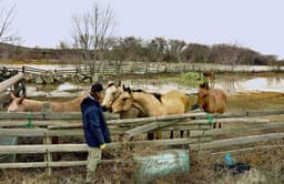
- Multiple levee breaks have occurred, exacerbating ongoing flooding.
- High winds and heavy snow are expected to impact mountain passes.
- Several major rivers are forecast to reach flood stages this week.
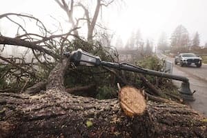
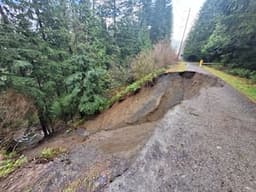
A series of weather events is impacting the Pacific Northwest, with alerts issued through Thursday. Flash Flood Warnings were in effect due to a levee break on the White River, marking the second such incident recently and adding to ongoing flooding from a previous atmospheric river. High Wind Warnings are in place for Seattle, Bellingham, the San Juans, and the Cascade Foothills, with gusts possibly reaching over 55 mph, increasing the risk of power outages and downed trees.
Heavy snow is anticipated in the mountains, with snowfall rates potentially overwhelming plowing operations. Snoqualmie Pass could see 3-6 inches of snow on Wednesday alone, accompanied by gusty winds creating whiteout conditions. Lowland areas will experience rain and cooler temperatures, with river flooding expected to peak on Wednesday. The Skagit River is forecast to reach major flood stage, while several other rivers will be in moderate flood stage.
Flooding on the Green, White, and Cedar Rivers is expected to persist through the weekend due to upstream dam releases. While this round of flooding is significant, it is not predicted to reach the severity of last week's events. Cooler temperatures are setting in, and while lowland snow is not anticipated, a rain-snow mix is possible in northern foothills. This shift to a cooler pattern is expected to reduce river flood and landslide threats by the end of the week.