Home / Weather / Ohio Faces Severe Storms, Then Cooler Weather
Ohio Faces Severe Storms, Then Cooler Weather
5 Apr
Summary
- Severe thunderstorm warnings issued for Darke and Miami counties.
- A level two out of five severe weather risk is in effect.
- Temperatures will drop significantly after the storms pass.
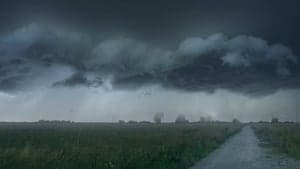
A cold front is poised to bring a threat of severe storms across Ohio, followed by a significant drop in temperatures. As of Saturday afternoon, a Severe Thunderstorm Warning is in effect for Darke and Miami counties until 3 p.m. Additionally, a Severe Thunderstorm Watch has been issued for Auglaize, Champaign, Clark, Logan, Miami, and Shelby counties, valid until 9 p.m. tonight.
The primary concern for potential severe weather, which falls under a level two out of five risk, lies within a window between 2 p.m. and 9 p.m. Residents should be aware of the possibility of damaging straight-line winds or isolated brief tornadoes, although widespread severe weather is not anticipated.
Following the storm activity, much cooler weather is expected. Easter weekend sunrise services are predicted to be seasonable but chilly, with early morning temperatures likely in the upper 30s and low 40s. Daytime highs will struggle to reach near 50 degrees, necessitating warm clothing.