Home / Weather / NOAA Aircraft Hunts Western WA Storm
NOAA Aircraft Hunts Western WA Storm
9 Dec
Summary
- NOAA's hurricane hunter aircraft deployed to study Western WA storm.
- Widespread flooding and damaging winds threaten the region Monday-Wednesday.
- Rainfall expected to be equivalent to a month's worth in just days.
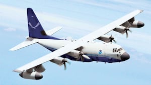
Western Washington is preparing for a significant weather event as a powerful atmospheric river approaches, bringing widespread flooding and damaging winds from Monday through Wednesday. In a rare move, NOAA is deploying its hurricane hunter aircraft to gather critical data directly from the storm system over the Pacific Ocean. This specialized plane will collect real-time information to refine forecasts as the system makes landfall.
The approaching storm is predicted to drop three to five inches of rain across the Seattle metro area, an amount comparable to its average rainfall for November or December. Multiple rivers, including the Snoqualqumie, Skagit, Skykomish, and Cowlitz, are expected to reach major flood stages by Tuesday and Wednesday. Hazardous wind gusts of 40-55 mph are also anticipated in two distinct pulses on Monday.
Beyond riverine flooding, residents face risks of urban flooding due to saturated soils and clogged storm drains, as well as potential landslides on saturated hillsides. While the storm has been downgraded from a Category 5 to a Category 4 atmospheric river, it remains an exceptionally strong system. The data from the hurricane hunter aircraft is crucial for meteorologists to provide the most accurate predictions and warnings.