feedzop-word-mark-logo
searchLogin
Feedzop
homeFor YouIndiaIndia
You
bookmarksYour BookmarkshashtagYour Topics
Trending
trending

Anil Ambani properties attached

trending

CAPF posts increased

trending

DAX index starts higher

trending

OpenAI Amazon $38bn cloud deal

trending

Afghanistan earthquake: Casualties feared

trending

NABARD promotes climate-resilient agriculture

trending

NSE holiday on November 5

trending

Titan shares rise after profit

trending

Coal India dividend announced

Terms of UsePrivacy PolicyAboutJobsPartner With Us

© 2025 Advergame Technologies Pvt. Ltd. ("ATPL"). Gamezop ® & Quizzop ® are registered trademarks of ATPL.

Gamezop is a plug-and-play gaming platform that any app or website can integrate to bring casual gaming for its users. Gamezop also operates Quizzop, a quizzing platform, that digital products can add as a trivia section.

Over 5,000 products from more than 70 countries have integrated Gamezop and Quizzop. These include Amazon, Samsung Internet, Snap, Tata Play, AccuWeather, Paytm, Gulf News, and Branch.

Games and trivia increase user engagement significantly within all kinds of apps and websites, besides opening a new stream of advertising revenue. Gamezop and Quizzop take 30 minutes to integrate and can be used for free: both by the products integrating them and end users

Increase ad revenue and engagement on your app / website with games, quizzes, astrology, and cricket content. Visit: business.gamezop.com

Property Code: 5571

Home / Weather / Newfoundland Faces Powerful November Storm Fueled by Bombogenesis

Newfoundland Faces Powerful November Storm Fueled by Bombogenesis

3 Nov

•

Summary

  • Rapidly intensifying weather system approaching Newfoundland
  • Potential for intense wind gusts, heavy rainfall, and snow
  • Storm expected to undergo bombogenesis, a rapid deepening process
Newfoundland Faces Powerful November Storm Fueled by Bombogenesis

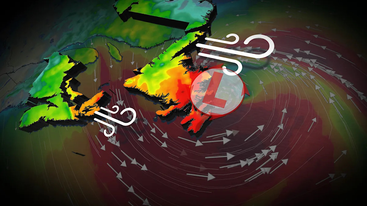
On November 3rd, 2025, a significant storm is developing and showing signs of rapid intensification. By Monday afternoon, a deep, cut-off trough is expected to interact with the warm waters of the Gulf Stream, generating a sharp temperature contrast between the ocean and the air.

Within 24 hours, a powerful low-pressure system is anticipated to approach Newfoundland. The storm will likely undergo bombogenesis, a rapid deepening process that turns the storm into a formidable low as it approaches Newfoundland on Tuesday.

Residents of Newfoundland and the surrounding region are bracing for the potential impacts of this powerful storm. Intense wind gusts of 90-100+ km/h are expected, with gusts exceeding 110 km/h possible, especially around Sable Island and southeastern coastal Newfoundland, including St. John's and the Avalon Peninsula. Heavy rainfall accumulations of 50-75 mm are expected in Cape Breton and along the Burgeo coast, with widespread amounts of 30-50 mm across the Avalon Peninsula. Wet snow may also develop in higher elevations in western Newfoundland and Labrador.

The combination of these weather conditions may lead to power outages, downed trees, minor structural damage, localized flooding, and coastal erosion due to large waves reaching 7-8 metres. Residents are advised to stay updated on the latest forecast and prepare for the potential risks to travel and infrastructure in the region.

Disclaimer: This story has been auto-aggregated and auto-summarised by a computer program. This story has not been edited or created by the Feedzop team.
The November storm approaching Newfoundland is a rapidly intensifying weather system that is expected to undergo bombogenesis, a rapid deepening process, leading to intense wind gusts, heavy rainfall, and possible snow.
The Newfoundland weather bomb is expected to bring intense wind gusts of 90-100+ km/h, with gusts exceeding 110 km/h possible, especially around Sable Island and southeastern coastal Newfoundland. Heavy rainfall accumulations of 50-75 mm are expected in Cape Breton and along the Burgeo coast, with widespread amounts of 30-50 mm across the Avalon Peninsula. Wet snow may also develop in higher elevations in western Newfoundland and Labrador, potentially leading to power outages, downed trees, minor structural damage, localized flooding, and coastal erosion.
The Newfoundland weather bomb is being fueled by a combination of factors, including a deep, cut-off trough interacting with the warm waters of the Gulf Stream, generating a sharp temperature contrast between the ocean and the air. This, combined with the phasing of two upper-level troughs, is creating the conditions for the storm to undergo rapid intensification or bombogenesis.

Read more news on

Weatherside-arrow

Advertisement

Advertisement

Advertisement

You may also like

Manx Salmon Thrive Despite Challenges: A Heartening Conservation Story

1 Nov • 8 reads

article image

Residents Revolt Against Billionaire Golf Course Takeover of Pristine Canadian Coastline

30 Oct • 13 reads

article image

Nova Scotia Couple Drills New $20,000 Well as 200-Year-Old Dug Well Runs Dry

29 Oct • 17 reads

Endangered Whales See Promising Population Growth Despite Ongoing Threats

21 Oct • 41 reads

Coastal Corridor Faces Tidal Threat: $650M Project Underway to Protect Critical Infrastructure

20 Oct • 55 reads