Home / Weather / Maryland Weather: Record Heat to Severe Storms, Then Arctic Blast!
Maryland Weather: Record Heat to Severe Storms, Then Arctic Blast!
11 Mar
Summary
- Record high of 85° in Baltimore Tuesday, with more warmth expected.
- Severe thunderstorms possible Wednesday with damaging winds and hail.
- Temperatures to plummet 30-40 degrees by Thursday morning.
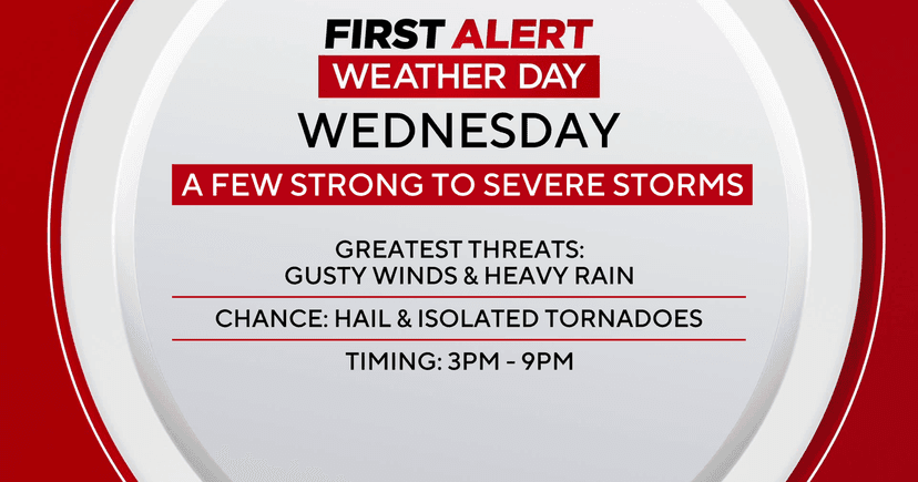
Maryland is experiencing a significant weather shift. After setting a record high of 85° on Tuesday, unseasonably warm temperatures continued into Wednesday, with highs potentially reaching 80° and breaking previous records. However, a strong cold front is expected to move through Wednesday night, bringing a First Alert Weather Day for severe thunderstorms.
The potential for severe weather, including damaging wind gusts up to 70 mph and hail, is greatest along and west of I-95 Wednesday afternoon into early evening. There is also a low risk of an isolated tornado. The Baltimore metro area's window for potential severe weather is between 3 p.m. and 9 p.m.
Following the storms, a dramatic temperature drop is anticipated. Thursday morning will feel 30 to 40 degrees colder than Wednesday afternoon, with temperatures falling into the 40s and gusty winds. Showers are expected through Thursday afternoon, with a possibility of brief wet snow showers late in the day, though no accumulation is forecast.
Looking ahead, Friday will be dry but breezy and chilly, with highs in the low to mid-50s. A slight chance of sprinkles exists for Friday evening. Dry and blustery conditions are expected for Saturday, with slightly warmer temperatures Sunday before another front arrives. Monday will bring light rain and gusty winds, followed by plunging temperatures into the 20s by Tuesday morning, with a continued cold spell expected through the middle of the following week. There's a possibility of light snow with the colder weather, but impacts are expected to be minimal.