Home / Weather / Kanpur Shivers: Cold Wave Grips City Amidst Fog and Rain Fears
Kanpur Shivers: Cold Wave Grips City Amidst Fog and Rain Fears
1 Feb
Summary
- Kanpur division is experiencing a cold wave with no signs of relenting.
- Fresh western disturbance may bring heavy rainfall across Uttar Pradesh.
- Dense fog disrupted rail services, causing significant delays.

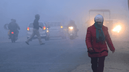
Kanpur and the surrounding division are currently experiencing a severe cold wave, characterized by cloudy skies and dropping temperatures. The India Meteorological Department (IMD) forecasts that a new western disturbance active over Himachal Pradesh and Uttarakhand will bring heavy rainfall to Uttar Pradesh from January 31 to February 1. This weather system is expected to cause minimum temperatures to fall nationwide over the next two days, intensifying the cold.
During the intervening night of January 30-31, Kanpur witnessed dense fog, followed by a noticeable drop in temperature, leading to a 'cold day' on Saturday. Minimum temperatures fell to 9.7 degrees Celsius, remaining above normal, while the maximum temperature reached 18.5 degrees Celsius. Weather experts predict that while mild sunshine might be visible due to cloud movement, strong winds will persist across Uttar Pradesh, causing temperature fluctuations and making nights even colder. There's a possibility of hailstorms in some areas and drizzle or light rain in the Kanpur division between February 2 night and February 3.
The prevailing fog has significantly impacted rail transportation. Numerous trains passing through or arriving in Kanpur experienced substantial delays, with some arriving several hours later than scheduled.