Home / Weather / Satellite Sees Stark Weather Split Across India
Satellite Sees Stark Weather Split Across India
26 Sep
Summary
- INSAT-3DS satellite captured contrasting cloud cover on Sept 24.
- A deep depression caused heavy rainfall in central and eastern India.
- Monsoon withdrawal left northwest India clearer and drier.
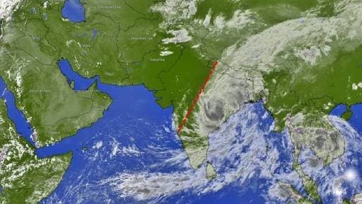
A recent image from India's INSAT-3DS weather satellite, captured on September 24, vividly illustrates a significant weather divide across the nation. While central, eastern, and southern India experienced dense cloud cover, much of the northwest remained clear.
This stark contrast was driven by a deep depression over north coastal Andhra Pradesh, which brought widespread rainfall to eastern and central regions. Simultaneously, the southwest monsoon began its seasonal withdrawal from northwest India, leading to drier conditions in that area.
The satellite imagery, utilizing thermal-infrared data, revealed that brighter areas corresponded to colder cloud tops, indicative of deep convection and potential heavy rainfall. This technology is crucial for meteorologists to monitor and track evolving weather systems.
Moisture from the Bay of Bengal continued to fuel the weather system affecting the east and south. This dynamic highlights how different parts of India can experience vastly different weather patterns during the monsoon's transitional phase.


