Home / Weather / Florida Heat Wave to Freeze: Storm Brings Wild Weather Flip
Florida Heat Wave to Freeze: Storm Brings Wild Weather Flip
23 Jan
Summary
- Florida forecasts shift from near-record heat to freezing temperatures.
- A strong cold front will bring a dramatic temperature drop Sunday night.
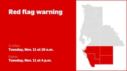
- Severe thunderstorms with isolated tornadoes are possible in the Panhandle.

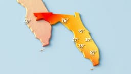
Florida is poised for a significant weather transformation as a major winter storm impacting much of the eastern U.S. is expected to bring a stark contrast to the Sunshine State. Following a period of heat waves with temperatures reaching near-record highs, a strong cold front is predicted to arrive Sunday night, Jan. 26. This front will usher in "bitterly cold temperatures" and a potential for hard freezes across inland areas. The Florida Panhandle and Big Bend region could experience severe thunderstorms on Sunday, Jan. 25, with a risk of damaging winds, isolated tornadoes, and waterspouts. As the cold front sweeps through Sunday night, temperatures are expected to crash into the upper teens to mid-20s. Inland areas could see lows in the teens by Monday night, Jan. 27, with wind chills potentially in the teens as well. For Northeast Florida, including Jacksonville, inland nightly freezes are anticipated from Monday, Jan. 26, through at least Wednesday night, Jan. 29. Cold weather advisories may be necessary Tuesday morning, Jan. 28, as wind chill values could fall into the low to mid-20s. Central and East Coast Florida, from Daytona Beach to Stuart, will also transition from near-record highs to below-normal temperatures by the end of January. South Florida, including West Palm Beach and Naples, will see high temperatures in the low to mid-80s before the cold front arrives Monday, Jan. 27, bringing temperatures potentially into the upper 30s west of Lake Okeechobee. Southwest Florida, from Fort Myers to Sarasota, will experience cooler air Monday, with overnight lows potentially dropping into the mid to upper 20s. Freezing temperatures are possible again Tuesday night/Wednesday morning, with a secondary cold front expected Wednesday night, Jan. 29, bringing more frigid air.