Home / Weather / East Coast Battles Blizzard: 4 Inches Per Hour Snowfall!
East Coast Battles Blizzard: 4 Inches Per Hour Snowfall!
23 Feb
Summary
- Snowfall rates of 2-4 inches per hour are expected to continue.
- Wind gusts up to 60 mph may cause blizzard conditions along the coast.
- Coastal flood advisory warns of up to a foot of inundation in low-lying areas.

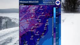
Residents along the East Coast are bracing for continued heavy snow and strong winds as a significant winter storm impacts the region. Snowfall rates of 2-4 inches per hour have been observed and are expected to persist through mid-morning on February 23, 2026. This intense snowfall, combined with fierce winds, is leading to blizzard conditions in many areas.
Coastal communities are particularly vulnerable, with wind gusts potentially reaching up to 60 miles per hour. This is contributing to blowing snow and treacherous travel conditions, which the National Weather Service has described as potentially life-threatening. Travel is strongly discouraged.
In addition to the snow and wind, a coastal flood advisory is active until 5 p.m. today. This advisory anticipates up to a foot of inundation in low-lying areas near shorelines, posing a risk to coastal roads. Residents are warned against driving through floodwaters, as their depth can be deceptive.
A storm warning is also in effect until 6 p.m. tonight, forecasting winds up to 45 knots with gusts reaching 55 knots, and seas up to 15 feet. All of South Jersey is currently under a blizzard warning, highlighting the severity of the ongoing weather event.