Home / Weather / Delhi Shivers: Cold Wave Grips NCR for Fourth Day
Delhi Shivers: Cold Wave Grips NCR for Fourth Day
15 Jan
Summary
- Minimum temperatures in Delhi-NCR plunged significantly, with one area hitting 2°C.
- Cold wave conditions have persisted for four consecutive days, impacting millions.
- A gradual temperature rise is expected from Friday due to approaching western disturbances.
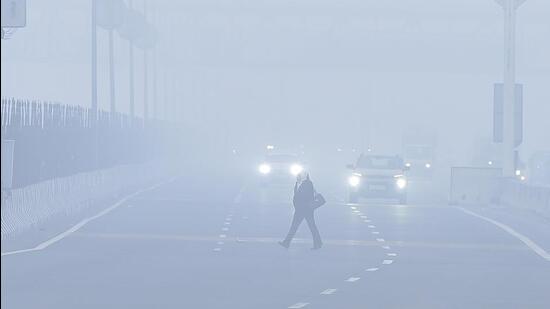
Delhi-NCR continues to be gripped by a relentless cold wave, marking its fourth consecutive day of extreme chill. Minimum temperatures have dropped drastically, with Gautam Budh Nagar recording 2°C and Delhi and Gurugram hovering just above 3°C. These harsh conditions, characterized by sharp winds and high humidity, have led to dense morning fog and even frost in less urbanized areas, a rare phenomenon for the plains.
Weather scientists attribute this prolonged cold spell to sustained northwesterly winds from the Himalayan region. The India Meteorological Department (IMD) has issued a yellow alert for Thursday, but forecasts a gradual increase in minimum temperatures starting Friday. This moderation is attributed to an approaching feeble western disturbance, which will shift wind patterns and bring milder, moisture-laden easterly winds.
Looking ahead, a series of stronger western disturbances are expected around January 16 and again from January 19-20, potentially bringing significant snowfall to the western Himalayas and rain to the plains later in the month. This will help to further alleviate the severe cold wave conditions, with Delhi's minimum temperatures predicted to rise to 6-8°C by Friday and 8-10°C by Sunday. Meanwhile, air quality across NCR remains in the 'very poor' to 'poor' category.