Home / Weather / Atlantic Canada Braces for Weather Bomb
Atlantic Canada Braces for Weather Bomb
22 Feb
Summary
- A powerful nor'easter is set to impact Atlantic Canada on Monday and Tuesday.
- Snowfall totals ranging from 15-40 cm are expected across the Maritimes.
- Travel disruptions, flight cancellations, and potential power outages are anticipated.

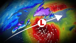
A powerful nor'easter is developing off the U.S. East Coast and is projected to hit Atlantic Canada by Monday afternoon, potentially reaching 'weather bomb' status. This rapidly strengthening storm is expected to bring significant disruptions across the Maritimes and Newfoundland.
Nova Scotia, New Brunswick, and P.E.I. are anticipated to receive the most intense snowfall, with amounts ranging from 15 to 40 cm. Newfoundland can expect 10 to 30 cm of snow. Blustery winds gusting up to 90 km/h in coastal areas raise concerns about coastal flooding and hazardous travel conditions, including whiteouts and reduced visibility.
Residents are advised to prepare for extensive travel delays, potential school and flight cancellations, and possible power outages. The storm's track is being closely monitored, as slight shifts could alter snowfall totals. As the system moves east on Tuesday, Newfoundland may experience a transition from snow to rain on the Avalon Peninsula, bringing a risk of localized flooding.