Home / Weather / Arctic Chill Spreads: US Faces Below-Normal Temps
Arctic Chill Spreads: US Faces Below-Normal Temps
4 Dec, 2025
Summary
- An arctic air mass is causing below-normal temperatures across the eastern U.S.
- South Florida can expect cooler temperatures, with lows dipping into the 50s.
- Millions of Americans will experience significantly colder weather than average.
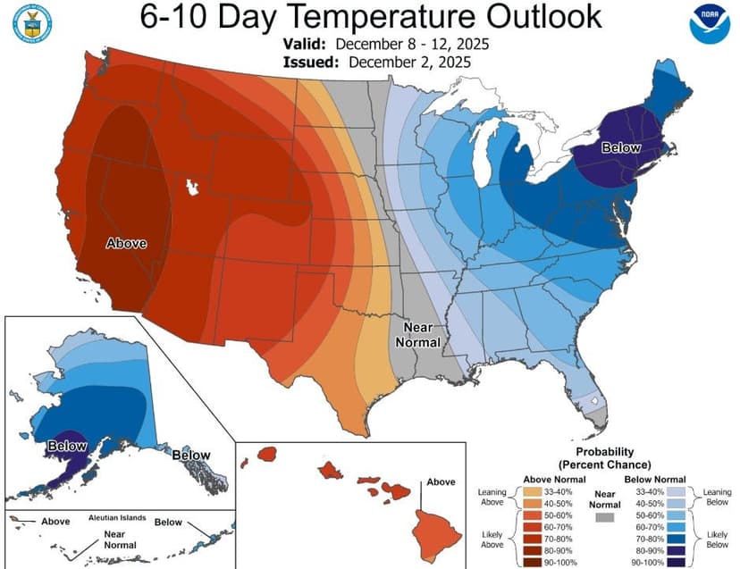
An arctic air mass is poised to bring a significant temperature drop to the eastern half of the United States, with below-normal conditions expected for approximately 220 million people. While the most extreme cold will impact northern regions, South Florida is also set to experience cooler weather next week, forecasting lows in the 50s and highs in the low 70s, a stark contrast to recent record highs.
This wintry blast is attributed to a displaced polar vortex settling near Hudson Bay. Areas across the Plains, Midwest, and Northeast have already endured and will continue to face repeat winter conditions. Some regions are predicted to be 15 to 25 degrees below average. Meanwhile, Florida's Panhandle could see overnight temperatures in the upper 30s to low 40s, with Central Florida near 50 degrees.
Despite the impending cold, meteorologists note that the air mass reaching Florida is a more 'tame' version of the arctic air impacting other parts of the country. The unique geography of South Florida, surrounded by water, often moderates extreme cold fronts. However, this shift marks a notable change from the unusually warm November, which saw several cities in Florida record their warmest Novembers on record.