Home / Science / Ocean's Hidden Highways Revealed!
Ocean's Hidden Highways Revealed!
5 Jan
Summary
- A new interactive map visualizes migration patterns of over 100 marine species.
- The MiCO map synthesizes data from over 1,300 studies conducted between 1990 and 2017.
- This tool aids conservationists and policymakers in understanding cross-jurisdictional migration.

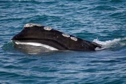
An innovative interactive map, Migratory Connectivity in the Ocean (MiCO), now illuminates the migratory patterns of over 100 marine species. Developed through a collaboration of leading research institutions, this tool consolidates data from more than 1,300 scientific studies spanning from 1990 to 2017, showcasing global journeys and nearly 2,000 unique habitats. The map provides scientists and conservationists with unprecedented insights into how these species navigate across oceans.
Researchers aggregated extensive data, including satellite tracking information, to model these complex migratory routes for diverse species like green turtles and sperm whales. Each data point on the interactive map links to its original source study, ensuring transparency and facilitating deeper research. This visualization helps to understand the interconnectedness of marine life, even as new tracking data continually expands its scope.