Home / Environment / UK Braces for Mid-March Snow Barrage
UK Braces for Mid-March Snow Barrage
2 Mar
Summary
- Snowfall is predicted across large parts of the UK starting March 15.
- Temperatures are expected to drop to -1C, with up to 21cm of snow near Inverness.
- The Met Office forecasts variable conditions, with dry weather in the south and rain/snow in the north.

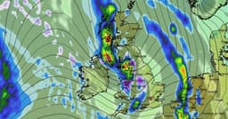
Wintry conditions are anticipated to affect the UK starting around noon on March 15, with snow expected to fall across extensive areas. Weather maps suggest temperatures could drop to as low as -1C, with accumulations of up to 21cm predicted in the vicinity of Inverness. These forecasts indicate a notable shift towards colder weather, impacting various regions of the country.
However, the Met Office's longer-range forecast for early March paints a more varied picture. High pressure is expected to dominate, leading to predominantly dry weather with variable cloud cover and sunshine, especially in the south and southeast. While patchy overnight frosts are possible, temperatures are generally forecast to be near or above average. Conversely, the north and west may experience frontal systems bringing rain, strong winds, and potential hill snow.
Further analysis from Netweather.tv for the week of March 9 to 15 suggests a continued likelihood of southerly or south-westerly winds, keeping most temperatures above average. The period is expected to be more unsettled than the previous week, with low-pressure systems bringing rain bands across the country, interspersed with brighter, showery weather. Eastern Britain, particularly eastern Scotland, might remain drier, while western counties, especially the southwest, could experience wetter conditions.