Home / Environment / Monster Hail, Tornadoes Roar Across Central US
Monster Hail, Tornadoes Roar Across Central US
17 Apr
Summary
- Severe storms forecast from Wisconsin to Texas by Friday afternoon.
- Hailstones over 3 inches in diameter and EF-3 tornadoes possible.
- Over 50 million people are in the path of dangerous weather.
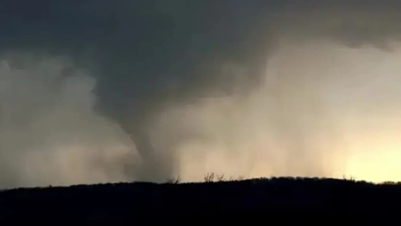
A significant severe weather system is expected to impact the Central U.S. early Friday afternoon, potentially affecting more than 50 million people. The threat zone stretches from Wisconsin down to Texas, warning of strong tornadoes, colossal hail, and hurricane-force winds.
The atmospheric setup involves a dip in the jet stream interacting with a boundary between dry western air and moist Gulf air. This combination is predicted to spawn supercell thunderstorms capable of producing EF-3 tornadoes, particularly in Wisconsin, Minnesota, and northeast Iowa, as well as parts of Kansas and Oklahoma.
Hailstones exceeding 3 inches in diameter are anticipated, posing a significant risk to property like vehicles and roofs. By Friday evening, damaging wind gusts of 75 mph or greater are expected to become a primary hazard across the Plains and Midwest.
This severe weather follows a week of destructive events in the region, including flooding in Wisconsin, Texas, and Kansas, and earlier tornadoes. The National Oceanic and Atmospheric Administration's Storm Prediction Center has placed a 700-mile corridor from near Oklahoma City through Kansas City, Missouri, and into La Crosse, Wisconsin, under a Level 3 out of 5 risk for severe thunderstorms.