Home / Environment / Sierra Snowpack Gains 5% Amid Icy Rain
Sierra Snowpack Gains 5% Amid Icy Rain
26 Feb
Summary
- Snowpack SWE rose 5% due to rain freezing into ice.
- Statewide snowpack is at 61% of average peak.
- Southern Sierra SWE is at 95% of normal.

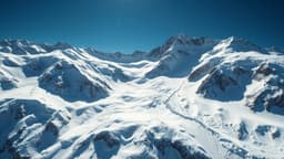
A recent warm storm has significantly impacted California's Sierra Nevada, causing rain to seep into the existing snowpack and freeze. This phenomenon has led to a notable increase in the snow water equivalent (SWE), a crucial metric for water supply planning. The statewide median SWE rose by 5 percent from Monday to Wednesday, reaching 75 percent.
While this is a positive development, the overall snowpack is still below average, sitting at 61 percent of its typical peak. Regional breakdowns show the Southern Sierra at 95 percent of normal, the Central Sierra at 74 percent, and the Northern Sierra at 54 percent. This recent gain follows back-to-back storms that also boosted reservoir levels across the state.
Experts highlight the importance of SWE, stating that increases, even those resulting from midwinter rain freezing, represent more stored water for the future. Meanwhile, developing El Niño conditions are predicted to potentially steer more storms toward the Colorado River Basin, offering some optimism for water reserves, though not a definitive solution to drought issues.