Home / Environment / NASA Images Show Critical Water Loss in Arizona
NASA Images Show Critical Water Loss in Arizona
25 Jun
Summary
- San Carlos Reservoir holds less than 1% of water capacity.
- Severe drought caused widespread fish deaths due to hypoxia.
- Summer monsoon may offer some hope for reservoir replenishment.
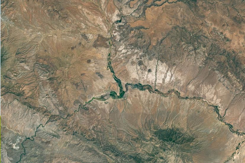
Satellite imagery from NASA starkly illustrates the critical water depletion at Arizona's San Carlos Reservoir. As of May 22, 2026, the reservoir, one of the state's largest, holds less than 1% of its capacity, a dramatic decline from 60% in June 2023. This severe reduction is attributed to prolonged drought conditions and necessary water releases for downstream agriculture.
The consequences are devastating, with nearly the entire fish population perishing due to a collapse in oxygen levels, a phenomenon known as hypoxia. This ecological disaster has forced the closure of the reservoir, raising concerns about decomposing fish posing health risks.
The San Carlos River watershed experienced minimal snowfall, resulting in significantly reduced spring runoff. This low inflow, coupled with continued water demands, exacerbated the reservoir's decline. This is not an isolated event, as similar low levels and fish kills occurred in 1976 and 2018.
Despite the current crisis, forecasts from NOAA suggest a 33-50% chance of above-average rainfall during the upcoming summer monsoon season. Additionally, an strengthening El Niño pattern may enhance the likelihood of heavy rains across the U.S. Southwest, potentially aiding the reservoir's recovery.